  The Streets of RomeIntroduction
The current network of streets in central Rome is, with some simplification, the result of five periods of growth of the
population and of the role of Rome. Streets of the same period have the same colour. Each period has its own numbering series. 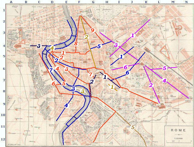
1912 Map of Rome Ancient Rome (brown lines in the map) 1) Via Sacra: in the Middle Ages the center of Ancient Rome became a cattle market (Campo Vaccino) with temples and arches partly buried in the ground. 2) Via Flaminia or Via Lata now Via del Corso: it was the initial section of Via Flaminia and it was located outside the
Servian walls, but it was included in the larger walls built by Aurelianus in 275 A.D. It became known
as Via Lata (lata in Latin means broad) because of its size and it acquired its current name towards the end of the XVth century when Paulus II
(1464-71) organized the first horse races (race=corsa) which started in Piazza del Popolo and ended in Piazza Venezia where he had built his palace. 3) Ponte Fabrizio or Quattro Capi and Ponte Cestio: Isola Tiberina, a little island in the river, was
an easy crossing place and the Romans built two bridges which withstood the action of floods and earthquakes. 4) Ponte Elio or Ponte S. Angelo: it was built by Hadrian with the sole purpose to provide an appropriate access to his Mausoleum,
but after the collapse of Pons Neronianus or Triumphalis, it became the only access to the Vatican. 5) Via Appia now Via delle Terme di Caracalla and Via di Porta S. Sebastiano: in the Servian walls Via Appia started at Porta Capena, but
Aurelianus in 275 A.D. included its initial section in the new walls of Rome. The street is now named after the Baths of Caracalla and the gate of S. Sebastiano.
Renaissance Rome (red lines in the map) 1) Via Recta or Via dei Coronari: it was part of the streets of Ancient Rome, but in the XVth century it was freed of medieval obstructions and paved with little stones.
It allowed pilgrims coming from the north and entering Rome through Porta del Popolo to reach Ponte S. Angelo and the Vatican. It was called Via dei Coronari because
there were many shops selling devotional goods to the pilgrims including rosaries and small crowns (hence Coronari).
2) Strada Papale or Via dei Banchi Nuovi and Via del Governo Vecchio: it was called Papal Street because
after his election the Pope went from the Vatican to St John's in Lateran (the Church of the Bishop of Rome) through this street. The various sections of the street were known
by other names. 3) Via dei Banchi Nuovi, Via del Pellegrino and Via dei Giubbonari: it was the street used by the pilgrims entering Rome
through Porta S. Paolo. It was enlarged by Alexander VI towards the end of the XVth century. 4) Via Giulia: it is named after Julius II, who at the beginning of the XVIth century did not hesitate to pull down many medieval buildings to renew the Roman tradition of designing straight streets. Via Giulia linked Ponte S. Angelo with Ponte Sisto. Vasi showed Via Giulia in the plate covering Palazzo Sacchetti (Plate 71) 5) Ponte Sisto: in 1450 a mule got restive on Ponte S. Angelo during a crowded Jubilee procession and
many people fell into the river. In view of the forthcoming 1475 Jubilee, Sixtus IV built on the site of Pons Aurelius a new bridge to facilitate the access
to the Vatican and avoid a repetition of the 1450 accident. 6) Via della Lungara and Via della Lungaretta: Julius II provided another link between Ponte Sisto and the Vatican by
opening Via della Lungara, a straight street between Porta Settimiana and Porta S. Spirito.
The street with the name of Via della Lungaretta continued inside Trastevere. 7) Via dell'Aracoeli: it was opened by Paulus III in 1536 to allow access to Palazzi del Campidoglio from the
western side of the Capitol hill. Its last section, a ramp, was designed by Michelangelo. 8) Via di Ripetta and Via della Scrofa: they were opened by Leo X in 1518 and they made it easier to reach Ponte S. Angelo from Porta del Popolo. 9) Via del Babbuino and Via Due Macelli: they were opened by Clemens VII in 1525 and they defined an area
between these two streets and Via del Corso which soon became known as the Strangers' Quarter, because of its many inns and taverns.
Late Renaissance Rome (magenta lines in the map) 1) Strada Pia now Via Venti Settembre: it was named after Pius IV. The purpose of the street was no longer related to facilitating
the flows of pilgrims to the Vatican, but to enlarging the populated area of Rome to the hills which once were the center of Ancient Rome. Strada Pia followed
the path of Alta Semita, a street of Ancient Rome, and it linked the Quirinal with Porta Pia a new gate designed by Michelangelo in 1561. It is now called Via Venti Settembre,
because on September 20, 1870 the Italian infantry troops, the bersaglieri, entered Rome through Porta Pia. 2) Via Tabernola or Strada della Nuova Suburra, now Via Merulana: in the last decades of the XVIth century the
construction of the new Basilica di S. Pietro did not allow any longer the use of the old basilica and the popes preferred
to transfer most of the religious ceremonies to the nearest major Basilica, S. Maria Maggiore.
Via Tabernola linked this basilica with S. Giovanni in Laterano and it was
completed for the Holy Year 1575. 3) Strada Felice now Via Sistina, Via delle Quattro Fontane and Via A. Depretis: it was named after Sixtus V (Felice Peretti) who between 1585 and 1590 put
S. Maria Maggiore (and his nearby Villa Peretti) at the center of a
star-shaped net of new streets. Strada Felice linked S. Maria Maggiore with Trinitŕ dei Monti. It crossed Strada Pia at
Piazza delle Quattro Fontane. It is now named Via Sistina (with reference to Sixtus V) from Trinitŕ dei Monti to
Piazza Barberini, Via delle Quatttro Fontane in the section near Piazza delle Quattro Fontane and Via A. Depretis (a XIXth century Prime Minister) in its last section.
4) Via di S. Croce in Gerusalemme, now also Via Carlo Alberto and Via Conte Verde: it was opened by Sixtus V and it linked
S. Maria Maggiore with S. Croce in Gerusalemme. It helped the pilgrims in their visit
of the seven basilicas. Sections of the street are now named after members of the Savoy family. 5) Via di Porta S. Lorenzo (lost): it was opened by Sixtus V and it linked
S. Maria Maggiore with Porta S. Lorenzo and Basilica di S. Lorenzo fuori le Mura.
It helped the pilgrims in their visit of the seven basilicas. The area near Porta S. Lorenzo was largely modified in the XIXth century and the street does not exist any longer. 6) Via Panisperna: it was opened by Sixtus V and it linked
S. Maria Maggiore with Piazza della Colonna Traiana. It is named
after the church of S. Lorenzo in Panisperna, where during some medieval ceremonies bread (panis) and ham (perna) were distributed. 1) Via Nazionale: it was opened in the 1870s with the purpose of making it the main street of the capital of the Italian Kingdom. The side streets are named after
the main Italian cities (Milan, Turin, Florence, etc). It linked the central Railway Station (Stazione Termini) with Piazza Venezia. 2) Corso Vittorio Emanuele: it is parallel or it follows Strada Papale. It was constructed in the 1870s by connecting some little squares or by
enlarging existing streets, so although most of the buildings are of the XIXth century, it is flanked by some old palaces and churches. It linked
Piazza del Gesů with the Vatican. 3) Via Arenula and Ponte G. Garibaldi: they were built in the late XIXth century to provide an easy access to Trastevere.
Via Arenula was opened by cutting through the houses of Regola, one of the historical quarters of Rome. 4) Viale del Re, now Viale Trastevere: this large avenue provided Trastevere with a new main street, which split the quarter in two sections, a major one centered around S. Maria in Trastevere and a minor one centered around S. Cecilia. 5) Via del Tritone: until the end of the XIXth century Via del Tritone was a little street leading to Bernini's
Fontana del Tritone in Piazza Barberini. The current Via del Tritone which replaced the old one is a large street linking
Piazza Colonna with Piazza Barberini. 6) Via Cavour: it was opened in the 1870s to provide a link between the new intensively built area near the central Railway Station with Campidoglio. The last section was not completed because of the growth of a more cautious approach to opening new streets in populated areas. 7) Lungotevere: in December 1870 Rome was flooded and the event led the Italian Government to build high walls along the Tiber and two large streets
at the two sides of the river. With the exception of S. Giovanni dei Fiorentini all the churches near the river were pulled down.
XXth Century Rome (black lines in the map) 1) Via dell'Impero, now Via dei Fori Imperiali: in the 1930s a new large avenue linked Piazza Venezia with the Colosseo. The new avenue led to pulling down the medieval area which had been spared by the decision not to complete Via Cavour. 2) Via del Mare, now Via A. Petroselli: it is a large avenue opened in the 1930s by pulling down a medieval area between Campidoglio and Teatro di Marcello. 3) Via della Conciliazione: it was designed in the 1930s, but it was completed for the Holy Year 1950. It provided a grand entrance to Piazza S. Pietro, but several palaces and churches were pulled down to achieve this dubious result. Other Directories Historical Roads of Rome The Silent Streets of Rome or to
The Coats of Arms of the Popes or
to My Home Page on Baroque Rome or to
My Home Page on Rome in the footsteps of an XVIIIth century traveller or to
The Coats of Arms of the Popes or
to My Home Page on Baroque Rome or to
My Home Page on Rome in the footsteps of an XVIIIth century traveller
|
All images © 1999 - 2003 by Roberto Piperno. Write to romapip@quipo.it