At the end of the Carthaginian wars (146 B.C.) Rome acquired two provinces (Sicily and Africa, then the name of today's Tunisia)
which were great producers of cereals (Sicily was later on called the granary of the Empire). The most important Roman families acquired
large estates in these provinces and at the same time through their control of the Senate they decreed the free
distribution of wheat to the inhabitants of Rome (frumentationes). The wheat bought by the Senate came from the new provinces,
leading from one side to the abandonment of agricultural land in continental Italy and eventually to the expansion of
marshes along its coasts and from the other side to the development of maritime routes and ports to ensure the constant supply
of a growing metropolis.
The river harbour of Ostia became so important that Mario and Silla fought
for its possession as they considered it a strategical point for the control of Rome. With the conquest of Egypt, another large supplier of crops, and the increased population of Rome,
the Emperor Augustus considered the creation of an artificial port near Rome because Ostia was affected by silting caused by winter floods.
Augustus' plan was implemented by Claudius and completed by Nero in 54 A.D.: the new port (called Portus Augusti) was located a few miles north of Ostia and linked
to the Tiber by an artificial channel, thus creating an island (Isola Sacra) between the two branches of the Tiber and the sea.
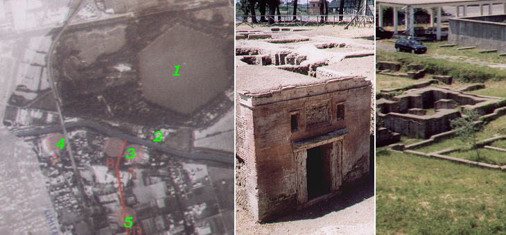
Map of the area, Necropolis and Baths
In 103 the Emperor Trajan enlarged the port by digging a new inner basin having a perfectly hexagonal shape (Portus Traiani).
The basin was surrounded by warehouses and granaries built according to advanced masonry standards aimed at ensuring appropriate
ventilation and temperature to the stocked goods. The current coastline runs some two miles to the west of Portus Augusti and in the aerial view
shown above the new land is printed very lightly to highlight the old coast line: the numbers indicate: 1) Portus Traiani; 2) Episcopio (Bishop's palace) di Porto; 3) Basilica di S. Ippolito; 4)
Roman Baths: 5) Necropolis.
Porto retained its role of terminal of the maritime routes supplying Rome until the VIth century, when the wars between the Byzantines and the Goths (535-553) for the control of Rome
ended up causing a dramatic decrease of its population and a spoliation of its treasures. In the VIIth century the Arab expansion
put the final seal on the decline of Porto by cutting its links with the Egyptian, Libyan and Tunisian ports.
Porto had a very cosmopolitan population, as it attracted merchants from all parts of the Roman Empire. A large necropolis shows that its
inhabitants were buried in well built family chapels and that some private villas had their own baths.
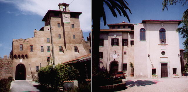
Episcopio di Porto
In 314 A.D. one year after the Edict of Milan, by which the Emperor Constantine had granted to the Christians the right to
openly profess their faith, Porto had its bishop. In the XVth century when marshes covered Porto and only
herdsmen ventured their lives
for pasturing their cattle in a land stricken with malarial fevers, the importance of Porto was revived by the decision of the popes
to appoint the most prominent cardinals, bishops of Porto, or of Ostia. The diocese
of Porto was a suburbicarian see: the cardinal who held this post was a likely candidate to the papacy.
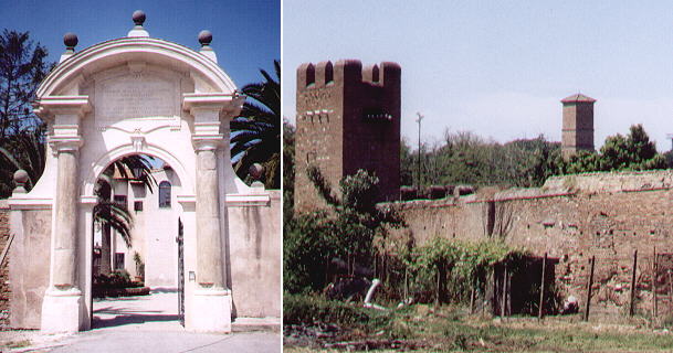
XVIIIth century gate and a section of the walls (in the distance the bell tower of S. Ippolito)
The palace where the bishops of Porto
lived was built in the XVth century and due to its isolation and to the possible landing of corsairs it was fortified. In the map of the area
painted in the Vatican
Palace it is called Castello (castle).
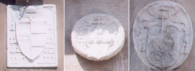
Coats of arms of Cardinals Borgia (Alexander VI), Piccolomini (Pius III),
Ciocchi del Monte (Julius III) in Episcopio di Porto
Some of the cardinals who were bishops of Porto in the XV/XVI centuries were eventually appointed popes.
Se vai a Porto, torni morto (If you go to Porto, you will come back dead) this lugubrious
warning had its impact on the bishops of Porto: as their diocese included the right bank of the Tiber from the sea to Trastevere and Isola Tiberina they preferred to live in Rome
and have a delegate taking the risk of presiding over the bishop's palace in Porto.
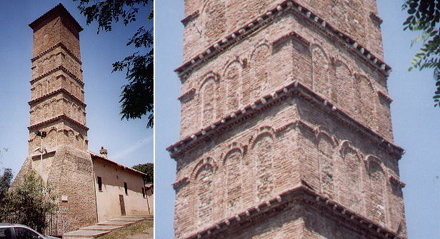
Bell tower of S. Ippolito
The church of S. Ippolito according to the tradition was dedicated to a bishop of Porto killed during a persecution. It shows
that the area was populated in medieval times and then abandoned, most likely when the nearby new bishop's palace offered a safer
location. Its XIIth century bell tower was turned into a watch tower in 1579 by Pope Gregorius XIII. Because it was already
far from the coastline its height was increased.
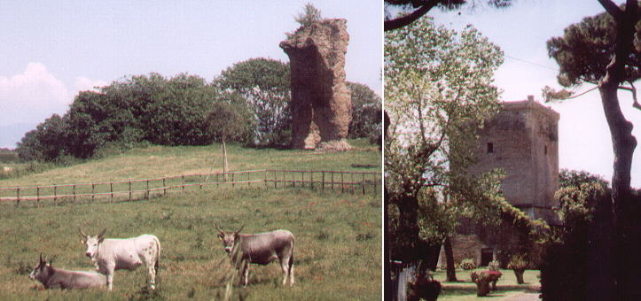
Ruins of Tempio di Portuno and a Renaissance watch tower
In the first decades of the XXth century the whole area of Porto was reclaimed and malaria was eradicated.
In the 1950s its northern part was chosen to locate the new International Airport of Rome, known as Roma Fiumicino (officially dedicated to Leonardo da Vinci).
The excavations led to the discovery of five Roman ships which are now on exhibition in a small museum at the airport.
By walking in the now redeemed countryside it is possible to come across other monuments of the past, included in farms or private residences.
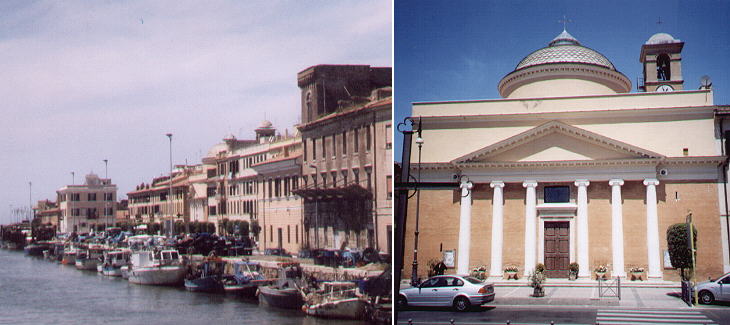
Fiumicino and S. Maria della Salute
The whole area of Porto was acquired by the Torlonia family in the late XVIIIth century: heirs of the Torlonia still own the area
around the hexagonal lake, which once was Portus Traiani and now it has been turned into a small park. Unlike
most of the other Roman prominent families they did not owe their wealth to the favour of a pope, but to their entrepreneurial skills. This led
the Torlonia to try to improve the value of their newly acquired possessions by founding a little town at the mouth of the once
artificial channel dug by the Romans to link Porto with the Tiber. Fiumicino, after fiume, river, has a neatly designed water front and
a fine Neoclassic church, both by Giuseppe Valadier, the architect most known for reshaping Piazza del Popolo.
Excerpts from Giuseppe Vasi 1761 Itinerary related to this page:
Porto Romano, città distrutta
Fuori di porta Portese camminando si giunge dopo 14. miglia al celebre e
magnifico Porto Romano, ora distrutto dal tempo, e per la
trascuraggine. Claudio Imperatore piantollo sulle foci del Tevere, affine di rendere Roma abbondante di viveri e di mercanzie, e però
fu l'emporio di tutte le nazioni, ed il luogo del commercio di tutto il Mondo. Fecevi una gran torre a similitudine di quella di Alessandria, e
nell'imboccatura vi pose un gran colosso rappresentante Augusto, che pensato aveva di fare sì grande opera. Trajano fecevi smisurati
portici, e magazzini, e Costantino Magno per fare a Roma un forte antemurale contro le invasioni de' nemici fecevi un accrescimento
notabile, onde Costantiniana fu detta: e fu tale il concorso de' popoli dell'Affrica, dell'Egitto, e di tutte le provincie dell'Impero Romano,
che divenne famosissimo il porto, e ricchissima la città. Restò spopolata quella città dopo l'edificazione della città Leonina, e però da
s. Leone IV. vi fu posta una colonia di Corsi; ma ora è alloggio di pecorari e di pescatori, che vi hanno erette fra le rovine alcune
capanne, e vi è una piccola chiesa dedicata a s. Biagio.
E' notabile, che essendo vescovo di detta Città s. Ippolito, sotto Alessandro Imperatore legate le mani e i piedi fu gettato ivi in un pozzo.
Egli era venuto dall'Oriente per visitare i sagri Limini e cimiterj; ma il Pontefice s. Calisto conoscendo la sua santità, creollo vescovo di Porto,
dove intento alla propalazione della Fede, in odio di questa acquistò la corona del martirio: onde i Cristiani ebbero tanta venerazione a quel
Santo, che vi eressero una statua, la quale ora sta nella biblioteca Vaticana, e sopra la di lui sepoltura fabbricarono una chiesa, che nelle
disgrazie di Porto soggiacque anche essa; si conserva però il pozzo, ove fu gettato il Santo, e i vestigj dell'antica confessione. Furono
similmente martirizzati nella città di Porto s. Giacinto, e li ss. Marziale, Saturnino, Epiteto, Maprile, Felice e compagni, ed ancora 50.
soldati; e poi i ss. Eutropio, Zosimo e Bonosa, ed altresì s. Ninfa vergine Palermitana, la quale essendo sbarcata con suoi compagni nel porto Romano, stette nascosta in una grotta, ivi vicina, nella quale fu poi con i compagni sepolta; e però vi fu edificata una chiesa. Molti
altri Santi, che noi per brevità tralasciamo, col glorioso loro martirio illustrarono quelle contrade; ma non già conviene tacere le glorie delle
sante sorelle Rufina e Seconda nobilissime donzelle Romane.
|
See my Home Page on Baroque Rome or my
Home Page on Rome in the footsteps of an
XVIIIth century traveller.
|